")
")
")
")
")
")

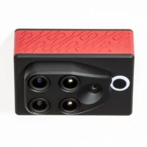
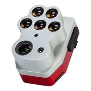
Parrot SEQUOIA+ Multispectral Sensor available in India
₹490,000.00
- Four-band multispectral imaging (Green, Red, Red Edge, Near Infrared)
- High-resolution 14MP RGB camera for crop scouting
- Built-in GPS and IMU for precise geotagging
- Sunshine sensor for automatic light adjustment
- 64GB internal memory with expandable SD card slot
- WiFi and USB connectivity for easy data access
5 in stock
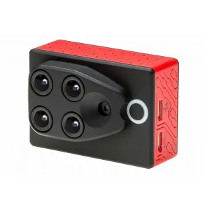
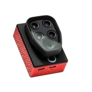
Parrot Sequoia Multispectral Camera
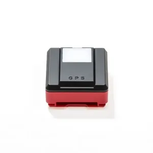
The Parrot Sequoia is a multispectral camera specifically designed to be compatible with all types of UAVs/Drones. This multispectral drone camera offers a comprehensive solution to precision agriculture, utilizing its two sensors – multispectral and sunshine – to analyze plant vitality by capturing the amount of light they absorb and reflect. This data provides invaluable information to farmers, helping them make informed decisions for their fields.
Revolutionizing NDVI Mapping
Gathering crop data for NDVI mapping is no longer restricted to mega farms with large budgets. Gone are the days of renting expensive satellite time or hiring helicopters.
All you need is a consumer drone and the Parrot Sequoia Multispectral Sensor, available from Aeromotus. Sequoia transforms consumer drones into agricultural mapping drones, helping farmers gather data that optimizes pesticide, herbicide, fertilizer, and irrigation usage. This enables the early detection of plant diseases, allowing treatment before it’s too late.
Compact and High-Precision Technology
Sequoia is a precision instrument despite its compact size and lightweight design. The downward-facing Sequoia sensor works in tandem with an upward-facing sunshine sensor. Together, they weigh less than 4 ounces. The Sequoia itself is less than 2.5 inches long, while the sunshine sensor is even smaller.
Key Features of Parrot Sequoia Multispectral Sensor:
- Four cameras capturing images in four bands: green, red, red edge, and near-infrared
- RGB camera recording 14MP images of crops
- GPS & IMU for precise image positioning
- Sunshine sensor for automatic light adjustments
- 64GB built-in memory for data storage
- SD card slot for expanded memory and easy data transfer
- WiFi & USB connectivity for data access
- Geotagging of images and data
- Compatible with multiple analysis services
- Adaptable for mounting on various drones (multi-rotor and fixed-wing)

How Sequoia Works
Sequoia is not just a single sensor—it’s an advanced camera system that gathers images and measures light from crops and their environment. Each reading is geotagged, allowing precise analysis of crop health, similar to NDVI satellite measurements.
Light Spectrum Captured by Sequoia:
- Green (550nm BP 40nm)
- Red (660nm BP 40nm)
- Red Edge (735nm BP 10nm)
- Near Infrared (790nm BP 40nm)
Each band is captured separately, producing detailed and accurate analysis superior to traditional multi-band sensors. The Sequoia adjusts for aircraft speed, height, and sunlight variations, ensuring consistent readings even under changing light conditions. The sunshine sensor attaches to the top of the drone for real-time adjustments.

In addition, the Sequoia has an RGB camera that’s useful for scouting field and crop conditions. It can snap up to one full-color image a second; it points downward, along with the other camera lenses.
Because all images taken by Sequoia are geotagged, you’ll know the exact location of the field or portion of a field in each image and in each piece of data. That means you can give your drone coordinates and it will go right back there, where you can use Sequoia’s RGB camera to scout the area of concern.

Sequoia Enables Informed Decision-Making
With a detailed crop map, farmers no longer have to make decisions field-by-field. Instead, they can apply pesticides, fungicides, fertilizers, and water only where necessary, optimizing costs and resources.
Timely interventions can save crops and even entire orchards by identifying diseases early and taking prompt action. Crop mapping also plays a crucial role in yield forecasting, improving agricultural productivity.

Plentiful Memory for Extensive Data Collection
The Sequoia comes with 64GB of internal memory, sufficient for approximately 8-10 flights, depending on flight parameters.
- Expandable storage: SD card slot allows additional memory
- Quick data transfer: WiFi & USB connectivity
- Easy access: Retrieve data directly from internal storage
A slot allows you to add memory with an optional SD card. That eases data transfer and allows you to record data from a single flight, then access or upload it quickly.
Data recorded on the internal memory can be accessed through built-in WiFI on each Sequoia or through its USB port.
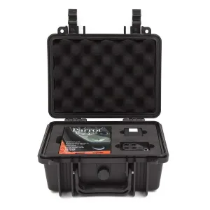
What’s Included in the Box?
- 1 Multispectral sensor
- 1 Sunshine sensor
- 1 Micro USBa-micro USBb cable (connects sensors)
- 1 Micro USBb-USB cable (connects multispectral sensor to drone)
- 1 Protection lens
- 1 Microfiber cloth
- 3 Sunshine sensor mounts
- 1 32GB SD card
- 1 User guide
- 1 Quickstart guide
The Parrot Sequoia is a game-changer for precision agriculture, bringing high-quality crop analysis to all farms, regardless of size. Its advanced features, ease of use, and affordability make it an essential tool for modern farming.
You must be logged in to post a review.
Related products
Out of stock
Out of stock
1 in stock
Out of stock

Available on backorder
Available on backorder
Reviews
There are no reviews yet.